DeskReport
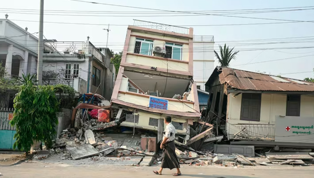
Geologists have been shocked by unprecedented video footage of the Earth’s surface moving during a devastating 7.7 magnitude earthquake in Myanmar. They are viewing the footage as a groundbreaking event in the field of seismology.
This scene of the earthquake was captured by a CCTV camera on March 28. On that day, a powerful earthquake struck the Southeast Asian country of Myanmar, affecting neighboring Thailand’s capital, Bangkok. According to the claims of the Myanmar military junta, at least 3,700 people lost their lives.
The video shows that during the earthquake, one side of the ground along the Sagaing Fault or Sagaing Fault Line moves with a strong jerk, as if the surface is bursting before our eyes. This change is most obvious on the right side of the video. It clearly shows that one side of the ground is being pushed a few meters away. The Sagaing Fault is about 1,400 kilometers long, which extends along the boundary of the Indian and Eurasian plates.
“I was blown away by the video,” said Wendy Bohn, a California-based geologist and science popularizer. “We usually imagine this scene with computer or lab models, but they are much less complex than reality.”
According to satellite and radar analysis by NASA’s Jet Propulsion Lab in the United States, the earthquake caused horizontal displacement of the ground in some places by up to 6 meters. The Japan Geophysical Agency also reported similar data.
Supershear earthquake hint
Cornell University geologist Judith Hubbard said the quake was likely a supershear earthquake, where the rupture in the crust spreads so fast that it travels faster than the seismic waves generated by the earthquake.
However, the video shows that the shaking starts first. Then the ground cracks—which suggests that the rupture was not spreading so quickly in this particular location. However, scientists believe that it could spread at supershear speeds in other parts of the fault.
The video was released on May 11 on the YouTube channel ‘2025 Sagaing Earthquake Archive’. The camera was at a power plant near the town of Thaji, which is located near the epicenter of the earthquake.
Wendy Bohn said she has no doubt that the video is real. The fine details in the video, such as birds flying in the air, power poles falling due to electric wires, etc., are not available in AI-made videos.
She added, ‘Earthquakes change the landform, and mountains and rivers move. The mountain that appears to be moving forward in the video is consistent with an underground fault line.
The CCTV camera was right where the rupture was happening and it was working—a very coincidental coincidence. Because these cameras are usually destroyed in earthquakes.
Scientists say the video will be of immense help to earthquake research. Usually, earthquakes destroy equipment or there are no sensors directly on the fault line. As a result, such direct video footage is rare and invaluable.
Bohn said, “At the same time, the video shows that small structures very close to the fault line were relatively intact. This tells us how the nature of earthquake damage changes with distance.”
Scientists say such footage will be even more important in the future. There are now millions of CCTV and mobile cameras around the world. As a result, it will be possible to collect more such examples of earthquakes.
“In the future, such videos will help us not only understand, but also develop future earthquake-resistant designs, building construction and policies,” said Bohn.
No matter how terrible a disaster, there are opportunities to learn from it, the scientists said. They hope that more CCTV or social media videos can play an important role in analyzing such disasters in the future.